This way action can be taken without having to wait for slow politics (in NL only party for the animals is serious on this matter) to do what health and fast-changing climate need NOW. More can be done for clean air and a better neighborhood for enjoying that (For Dutch readers some more detail in "opgeluchte wijk" on https://www.duurzamedinsdag.nl/index.php?id=17171&initiative=15444 )
In case you think wood smoke is not such a serious matter, you should take a look at https://houtrookvrij.nl/wp-content/uploads/2016/02/Bijdrage-uitstoot-consumenten-K-0219-2-liggend.jpg
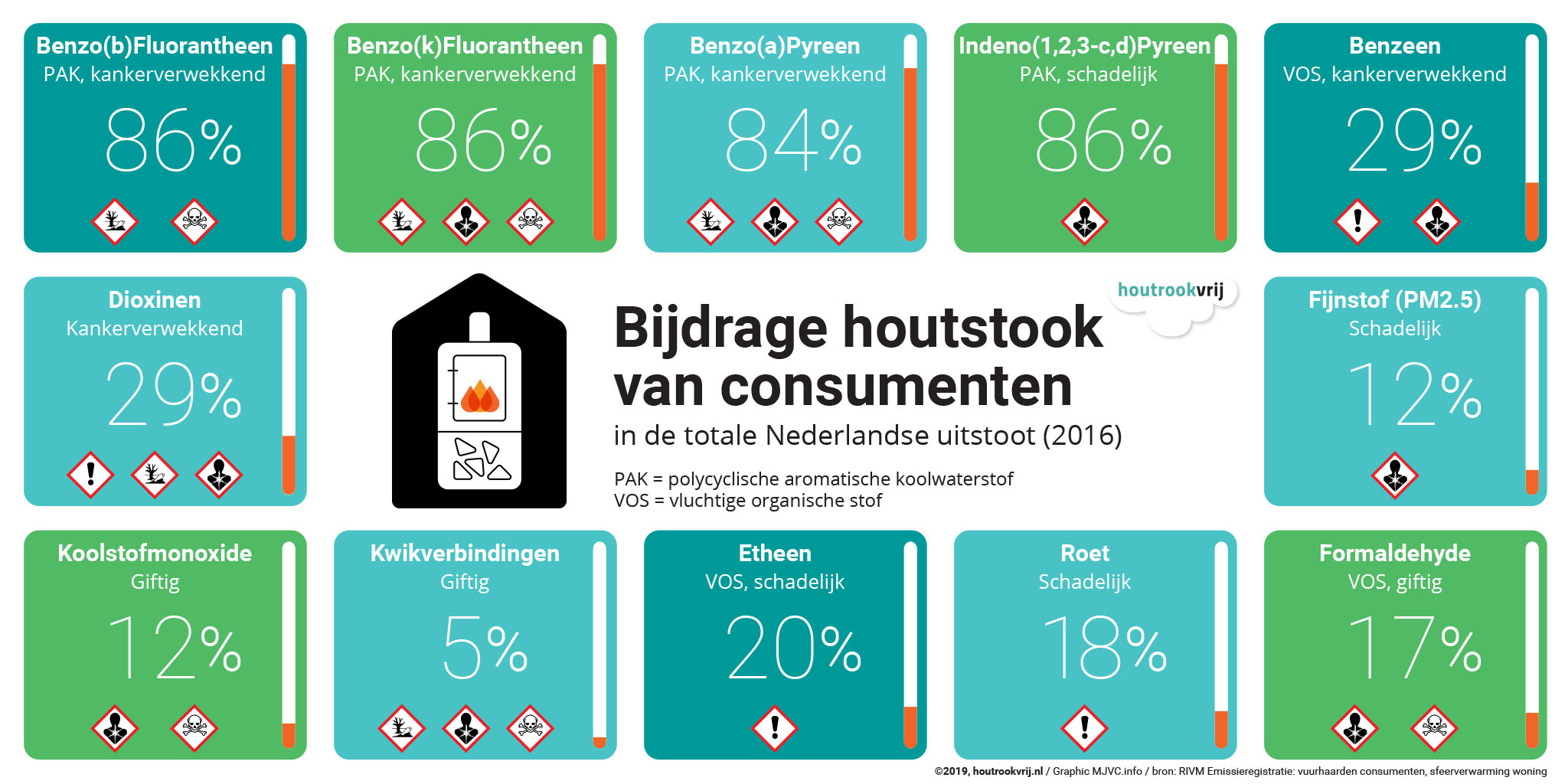
The #COVID19 pandemia (a LUNGvirus) is killing many more people where air pollution is high it seems, not surprisingly.
Recent success with something at least a little similar: "roken op het balkon of voor de deur? Het huurcontract wordt ontbonden"
And ask for lower WOZ-tax because of less valuable living in neighbor smoke. success story
For every vacation park or camping show if smoke is allowed on an easy to remember website?
Also see https://github.com/steltenpower/SmellOutStinkers
Also : 10 voor school; oproepen/nudgen om de 10 minuten voor school begint voor de autonomie van gezonde kinderen in te zetten en daarom auto's minder te faciliteren en natuurlijk ook de 10 minuten na sluiten school. Met communicatie, afsluitingen en positieve communicatie naar de wijk.
====================================
improving combinations of humans, sensors and algorithms to pinpoint sources of what you breath in. Towards an easy webapp to find and confront polluters
1e doel: Generieke visualisatie van lijstje coördinaten (ergens vandaan halen)
2e doel: Disclaimer schrijven
3e doel: Zorg dat ook niet-nerds coördinaten kunnen toevoegen
4e doel: Lijst van mogelijke toekomstige verbeteringen beginnen
5e doel: stapje voor stapje verbeteren en dat weer communiceren met de wereld om het onderwerp steeds in daglicht te zetten en specifiek ook de daders van deze ontbossing en vergiftiging.
highlighters: laser, flashlight, reactants, ...
sensor carriers: satellite, plane, helicopter, balloon, drone, projectile, (streetview)car, bike, pedestrian, climber, boat, ...
sensor, for smoke and/or chimney : visible light, infrared, a range of smoke detectors, distance, location, human/animal senses and communication media ...
registers (directly and indirectly, potentially): permits, buildings, ...
De beperkte bruikbare data en enorme diversiteit in schoorstenen en hun plaatsing maakt het trainen van een herkenningssysteem (momenteel bijna?) onmogelijk (een wetenschappelijk onderzoek dat zich beperkte tot hele grote gelijksoortige schoorstenen had zelfs geen fantastische resultaten), MAAR ...
-
Sommige wetenschappers worden juist uitgedaagd door taaie problemen.
-
met handwerk is ook al veel mogelijk, zie Wikipedia, OpenStreetmap, etc. Wellicht her en der ondersteund door hittecamera's (ook gebruikt voor huisisolatie-plannen)
-
Sensoren en algoritmes blijven zich ontwikkelen.
-
Mensen helpen ook Google richting zelfrijdende auto met fotoherkenning (Captcha, om te checken of je wel een echt mens bent), zelfde principe kan ook anders ingezet.
-
We kunnen alvast beginnen met een data-model voor stoken op een erf: datum, tijd, locatie, houthaard opgeslagen, bewerkt hout, schoorsteen, illegaal gemonteerd, stookt tijdens alert, hoogste buitentemperatuur, ...
@SensorCommunity If one could put a pin on your awesome map and then wind going through it would be highlighted could show where pollution is coming from and going to
Have a data layer where people can add chimneys, maybe with date&time of last known activity ?
Know of places where there's a register of chimneys? Know of algorithms that find them helped by human-in-the-loop, satellites (photo, infrared, height), streetview and other photos, real estate descriptions, or something else?
I suspect enabling quick user-interaction is key to start. When the data set grows enough, stronger suggestions can be made by algorithms.
Opslaan waar schoorstenen zich bevinden kan volgens https://help.openstreetmap.org/questions/6102/can-i-add-a-custom-layer waar je waarschijnlijk GitHub wel kan gebruiken om een groot KML bestand op te slaan. KML bestand is lijstje met coördinaten. Met Notepad kan je de eerste toevoegen, maar dat moet snel handiger om je hele omgeving te kunnen mappen en echt geavanceerd (obv allerlei databronnen een goede gok doen) wil je meer vastleggen dan een paar woonwijken. Over wat mag qua schoorsteen:
- https://iplo.nl/regelgeving/regels-voor-activiteiten/technische-bouwactiviteit/rijksregels-bouwactiviteit/technische-bouwregels-houtkachels/
- https://www.helpdeskbouwregels.nl/AfbeeldingById/10184
- https://www.prefabschoorsteenbouw.nl/wp-content/uploads/2019/10/Installatievoorschriften-.pdf
https://www.samenmetenaanluchtkwaliteit.nl/dataportaal/samen-analyseren-tool
https://www.atlasleefomgeving.nl/check-je-plek
https://www.goudappel.nl/nl/expertises/themas/klimaat-en-energie/inzicht-de-uitstoot-van-mobiliteit
Also see https://github.com/steltenpower/UnchokedNeighborhood
obv satellietfoto's achterhalen bronnen PM2.5 (ultrafijnstof, duizenden doden jaarlijks in NL, waarvan groot deel door hout- en pelletkachels) nu met resolutie van 200m x 200m. #houtrook Quote Tweet Ruud Steltenpool🤔🔗📊🚲👨👩👧👧💾🌳 @steltenpower · Aug 2 "PM2.5 was globally ranked as the fifth mortality risk factor ... While most of the current standard practices can predict levels down to 1 million square meters, the new method is accurate down to 40,000—about the size of eight football fields placed side-by-side." twitter.com/emirhartato/st…
Oh wow, did not expect that PlanetScope daily images can be used to measure air pollution 😮 https://pratt.duke.edu/about/news/air-pollution-satellites
Another related paper: https://mdpi.com/2072-4292/13/15/2981/htm
https://climatetrace.org/ (van Al Gore e.a.)
https://mashable.com/article/google-maps-solar-air-quality-pollen-api
Pinpoint locations and concentrations with 'mobile'device ? https://www.deingenieur.nl/artikel/pollensensor-voorspelt-hooikoortsgolf
Turn it into a photo-realistic First-Person (Chimney)-Shooter ?
Scapeler heeft iets met tijdelijk markeren rook/stank incident