Home
- Puget Sound Vital Signs (suites of indicators, updated annually)
- Puget Sound Metrics (oceanographic dashboard with weekly updates relative to climatology)
- PSEMP
- Community science initiatives
- Georgia Strait Alliance?
- Community science initiatives
-
OOI NSF
- Regional Cabled Array](https://interactiveoceans.washington.edu/about/regional-cabled-array/) off Oregon to Juan de Fuca plate boundaries
-
IOOS NOAA
- Northwest U.S. -- NANOOS
- ONC - Ocean Networks Canada
- LiveOcean (UW, Parker MacCready) Github account parkermac
- Salish Sea model (Ecology/PNNL/UW-Tacoma, Tarang Khangaonkar, et al.) accounts for freshwater input from 68 rivers and pollutant fluxes from 99 outfalls
- SalishSeaCast NEMO Model (UBC, Susan Allen, et al.) Github org SalishSeaCast
- SSCOFS model (NOAA; operational 2024)
- Ocean Connect (CIOOS Pacific and the Hakai Institute) Data sources
See also hydrodynamic and ecosystem model domain extents in the Acartia wiki (lat/lon bounds & images)
- Atlantis Model for Puget Sound Hem Morzaria, based on Australian Atlantis Ecosystem Model Framework (closed source) | Azure set-up | PS parameters repo | NOAA tech memo, April, 2022 ]
- Strait of Georgia ecosystem model (EcoSim? open source?)
Cetacean movement modeling
Whale "math" resources! These tools can help forecast how a cetacean may move through the Salish Sea, and therefore when and where it may be encountered next...
-
Salish Sea travel time spreadsheet (Google sheet; metric units; input any decimal speed in km/hr, but currently assumes 6-7 km/h for both SRKWs and Bigg's killer whales)

-
SpyHopper.ca "Whale math" travel time tool (map layer; nautical units; input speed in knots with three choices: slow=3, ave.=4.5, or fast=6 [5.5, 8.3, 11.1 km/h, respectively])

-
HALLO project's forecast models for SRKW movement (Peter Thompson in 2024-5; Teng-wei Lin in 2023-25 (2024-25) | Marine Randone's web page and publication (2022))
-
Other species?
- Anything for humpbacks in the Salish Sea? (since they are most commonly struck within Puget Sound)
- Harbor seals (e.g based on telemetry tag observations?)
- Porpoise distribution probability model based on zooplankton layers of the oceanographic models?
-
Habitat models
- Humpback density surfaces from ERMA
- Sounder gray whales?
- Atlas of pinniped haulouts?
-
Integrated models & frameworks
-
Puget Sound Integrated Modeling Framework launched in 2022 by PSI/UW to link VELMA (land management), Salish Sea (circulation), and Atlantis (ecosystem) models. This intro video suggests that it includes an effort to incorporate a
human dimensions modelto predict human well-being from environmental outcomes (salmon, orcas, green-spaces) through metrics for health, economic vitality, & equity. - European (Dutch, 2022) framework: noise impacts on marine mammals
-
Puget Sound Integrated Modeling Framework launched in 2022 by PSI/UW to link VELMA (land management), Salish Sea (circulation), and Atlantis (ecosystem) models. This intro video suggests that it includes an effort to incorporate a

- Human population status & growth models
- Most current population estimates:
- SRKW range: ??
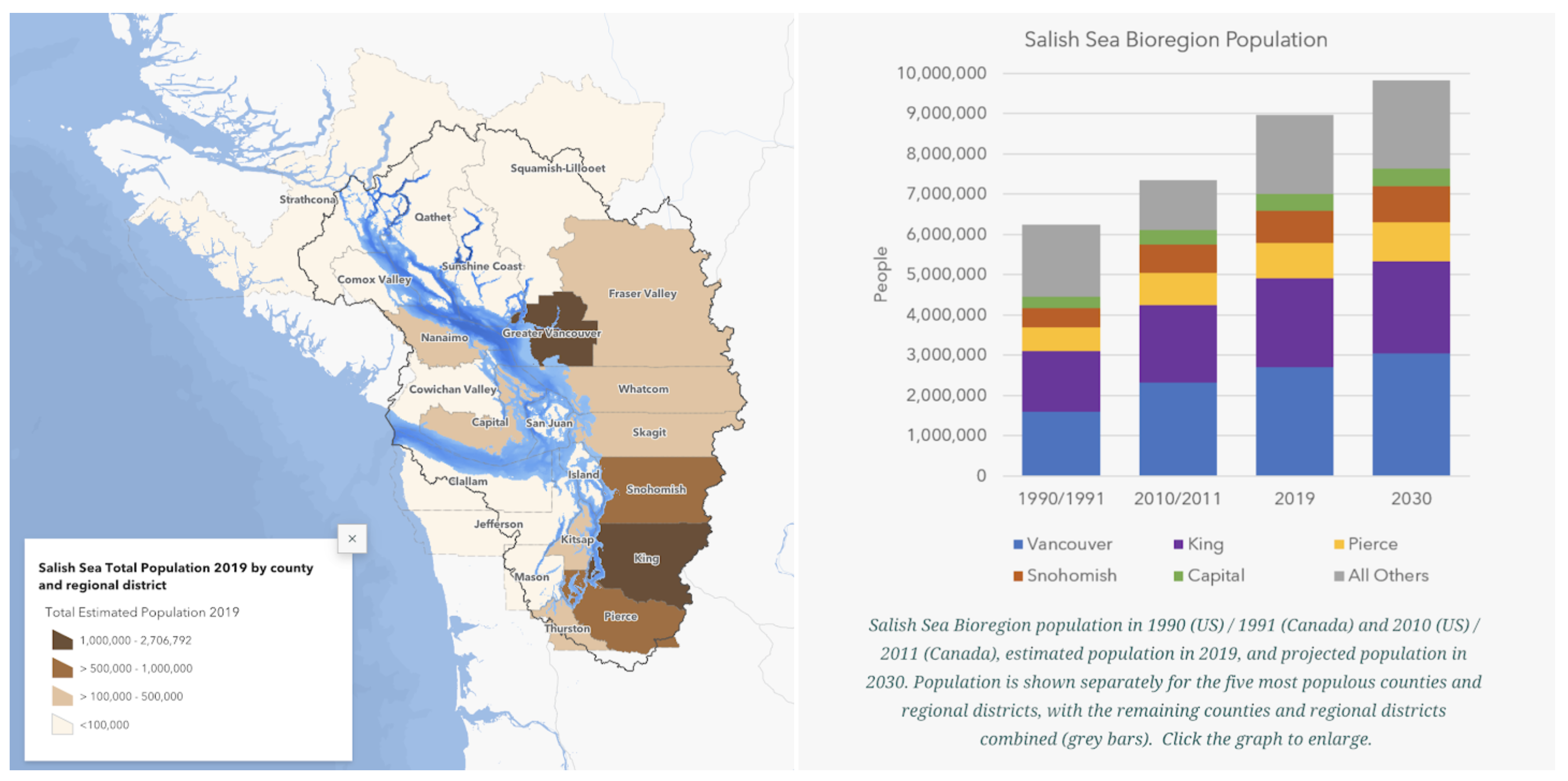
- Salish Sea region: 9 million in 2019
- Puget Sound: ??
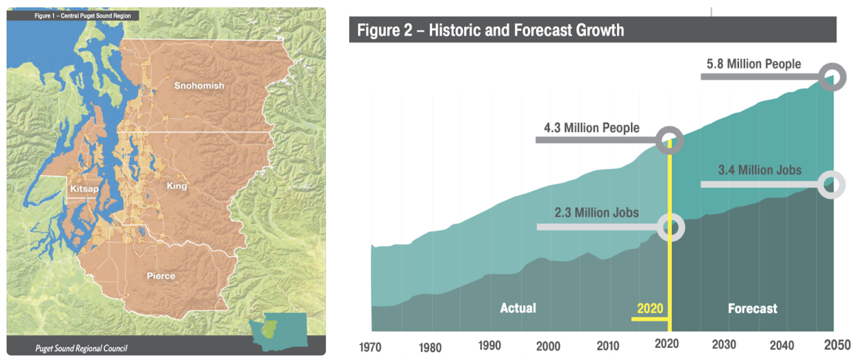
- Central Puget Sound: 4.3 million in 2020
- Human population of the Salish Sea Region GIS storymap (Salish Sea Atlas, Aquila Flower, 2021) -- 1990-2030:
- Most current population estimates:
- Puget Sound Regional Council's Vision 2050 (30y projection from 2020) includes this plot of past and projected human population (and jobs) for counties in "central Puget Sound"-- 1970-2050:
- Canadian regulations regarding marine mammal approach
- MERS boater laws and safety
- Be Whale Wise
- WDFW description of "No-go zone" on west side of San Juan Island
- Quiet Sound (US slow down area in Puget Sound)
- ECHO (Canadian slow down areas and lateral offsets)
- Wikis
- The Salish Sea on Wikipedia
- Salish Sea wiki
- Puget Sound wiki (fish and other species, general info)
- Encyclopedias and Atlases